
Satellite Systems
Providing high-performance satellite systems for Earth observation and other missions
Earth Observation Data Services
Providing high-resolution satellite imagery and other Earth observation data
AI-based GEOINT Solutions
Providing GEOINT solutions through AI-based satellite data analysis
SATREC INITIATIVE
Satrec Initiative was founded in 1999 by the engineers who developed the first Korean satellite and a series of advanced small satellites. We have been focusing on developing high-performance small/medium satellite systems for Earth observation missions.
Daejeon, Daejeon, South Korea
Aerospace
Products & Services
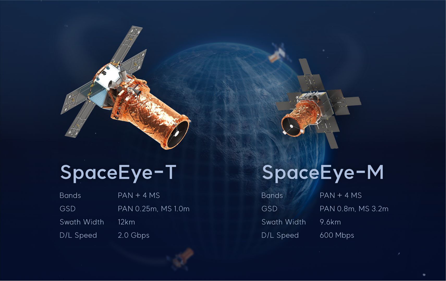
SpaceEye-M
Satrec Initiative
0.8m급 고해상도 초소형 지구관측 위성으로,
군집운용을 통해 고빈도 · 정밀 감시체계를 구축합니다.
SpaceEye-M is a small satellite to produce high-resolution image data.
A constellation of SpaceEye-M can perform precise monitoring over a large area with high revisit.
군집운용을 통해 고빈도 · 정밀 감시체계를 구축합니다.
SpaceEye-M is a small satellite to produce high-resolution image data.
A constellation of SpaceEye-M can perform precise monitoring over a large area with high revisit.
SpaceEye-T
Satrec Initiative
0.25m급 초고해상도 중형 지구관측 위성으로,
12km의 관측폭과 높은 기동성을 기반으로 정밀 데이터를 공급합니다.
SpaceEye-T is the first 0.25m resolution satellite built in Korea for commercial use.
SpaceEye-T is designed to collect VVHR image data with a wide swath for applications that require timely responses.
12km의 관측폭과 높은 기동성을 기반으로 정밀 데이터를 공급합니다.
SpaceEye-T is the first 0.25m resolution satellite built in Korea for commercial use.
SpaceEye-T is designed to collect VVHR image data with a wide swath for applications that require timely responses.
People
About
Satrec Initiative was founded in 1999 by the engineers who developed the first Korean satellite and a series of advanced small satellites. We have been focusing on developing high-performance small/medium satellite systems for Earth observation missions.
We have contributed to the success of over 30 international and domestic space programs to date.
Today, we provide remote sensing satellites, ground systems, and imaging services to AI-based geospatial analytics integrating the Earth observation value chain.
We have contributed to the success of over 30 international and domestic space programs to date.
Today, we provide remote sensing satellites, ground systems, and imaging services to AI-based geospatial analytics integrating the Earth observation value chain.