SeaHFlight - Digital Twin System for Low-Altitude Air Control
Real-time tracking
Tracks asset location, speed & status in real-time via satellite/LTE for rapid command decisions.
Situational Awareness
Dynamic 2D/3D GIS map fuses aircraft tracking with weather & airspace data for enhanced safety.
Mission Management
Manages the full mission cycle, from pre-flight planning to live monitoring and post-flight analysis
Interoperability
Can be integrated with military command and public safety agencies for
SeaHFlight - Digital Twin System for Low-Altitude Air Control
Digital Twin System for Low-Altitude Air Control
People

Description
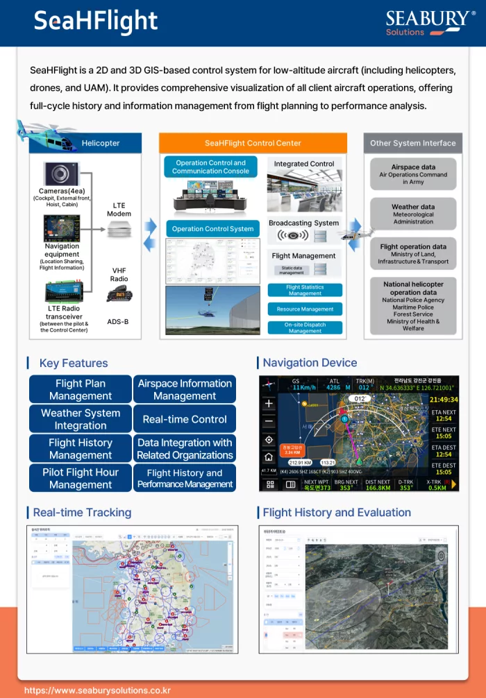
SeaHFlight is an advanced 2D/3D GIS-based command and control solution engineered for the comprehensive management of low-altitude aircraft, including helicopters, drones, and future UAMs. It provides a complete operational picture, offering full lifecycle management from initial flight planning and real-time monitoring to post-flight performance analysis.
Key Capabilities:
Unified Situational Awareness: Achieve superior decision-making with a dynamic 2D/3D operational map that visualizes all air assets in real-time. The system integrates crucial data layers, including weather, airspace information, and flight plans.
End-to-End Mission Management: Streamline the entire operational workflow, covering everything from flight plan creation and pilot hour management to flight history recording and detailed performance evaluation.
Proven Interoperability: SeaHFlight is designed for seamless data integration with key national and military agencies (Army, Police, National Fire Agency, Forest Service). This creates a unified network for complex, multi-agency public safety or defense operations.
Future-Ready Platform: Built to manage not only current helicopter and drone fleets but also the next generation of Urban Air Mobility (UAM), SeaHFlight is a scalable, long-term solution for modern aviation.