
GARMIN
Jakarta Barat, DKI Jakarta, Indonesia
Defense & Security
Products & Services
Garmin Radar CR1522 w/ GMR424xHD
Garmin
Built for shipping vessels and workboats, the CR 1522 is a 15-inch stand-alone radar OpenArray 4KW 72nm display with button and chart compatibility that offers critical information at a glance on its portrait display.
General
PHYSICAL DIMENSIONS 355 x 376.7 x 82.7 mm
SCREEN SIZE 15" diagonal, (228.1 x 304.1 mm diagonal)
SCREEN RESOLUTION 1024 x 768 pixels
SCREEN TYPE XGA
WEIGHT 3.7 kg (5.7 kg with mounting bracket)
WATER RESISTANCE RATING IP26 & IP27 (IEC60529)
POWER SUPPLY 10 to 36 VDC
POWER CONSUMPTION 2.71 A (Max. current draw @ 12 VDC)
3 A (Max. current draw @ 12 VDC)
ANTENNA External over BNC
MOUNTING OPTIONS Landscape and flush mount, hanging with optional accessories (Garmin does not offer any hardware or accessories for landscape mounting. Professional equipment and knowledge required required.)
10 Hz GPS/GLONASS/GALILEO/BEIDOU/QZSS/GAGAN AND SBAS RECEIVER
Multi-Language Support English, Simplified Chinese, Traditional Chinese, Japanese, Korean, Thai, Indonesian, Malaysian, Vietnamese, Myanmar, India, Gujarati
Maps & Memory
PRELOADED MAPS World basemap
Bluechart compatibility
ACCEPT DATA CARD 2 SD card slots; 32 GB storage Max.
WAYPOINTS 5,000
ROUTES 100
TRACTS 50 stored tracks
Radar Features & Specifications
pip zoom
Target tracking Up to 50 targets
radar overlay
dual range
dual protection zone alarm
dual ebl/vrm
radar chart orientation Forward
North
On Course
echo trails
off center
pi lines
vibration expansion
Connections
NMEA COMPATIBILITY 2000
NMEA 0183 COMPATIBILITY
BNC GPS Antenna
Related
Download Manual
Purchase Marine Navigation Charts
Support Center
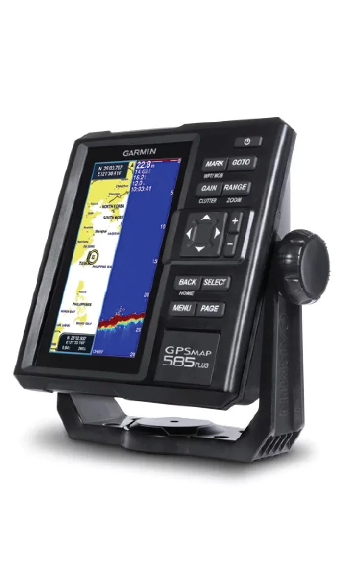
Garmin GPSMAP 585PLUS
Garmin
Navigate with GPS Colour Screen support with Ocean Map & built in Sonar( transducer optional)
Multi-language support: English, Simplified Chinese, Traditional Chinese, Japanese, Korean, Indonesian, Malaysian, Vietnamese, Myanmar, Thai.
Available in 6 inch WVGA color, portrait mode display. Offers a buttoned interface with special buttons.
Sonar CHIRP sends continuous frequency sweeps from low to high. Sonar CHIRP is able to display a sharper fish curve with better target separation.
The traditional CHIRP 600 W (RMS) internal sonar and the CHIRP ClearVü scanning sonar provide a clearer picture of what is under the ship as a photographic image with representations of objects, structures, and fish.
Compatible with powerful GPS, GLONASS, and BeiDou positioning systems, which quickly and easily provide up to 12,000 accurate directional points that allow you to find your way back to your secret fishing spot.
Included is a free and easy-to-use Quickdraw Contours software that instantly creates personalized HD fishing maps.
GPSMAP 585 Plus supports regular NMEA0183 and RS422 communication in third-party sensors and accessories.
2 standard SD™ card slots provide upgradeable memory for accessory map purchases such as LakeVü HD Ultra maps and BlueChart® g2 Vision® nautical maps
Garmin CR 1522 w/ GMR 18HD+2
Garmin
Built for shipping vessels and workboats, the CR 1522 is a 15-inch stand-alone radar Radome 4KW 36nm display with button and chart compatibility that offers critical information at a glance on its portrait display.
General
PHYSICAL DIMENSIONS 355 x 376.7 x 82.7 mm
SCREEN SIZE 15" diagonal, (228.1 x 304.1 mm diagonal)
SCREEN RESOLUTION 1024 x 768 pixels
SCREEN TYPE XGA
WEIGHT 3.7 kg (5.7 kg with mounting bracket)
WATER RESISTANCE RATING IP26 & IP27 (IEC60529)
POWER SUPPLY 10 to 36 VDC
POWER CONSUMPTION 2.71 A (Max. current draw @ 12 VDC)
3 A (Max. current draw @ 12 VDC)
ANTENNA External over BNC
MOUNTING OPTIONS Landscape and flush mount, hanging with optional accessories (Garmin does not offer any hardware or accessories for landscape mounting. Professional equipment and knowledge required required.)
10 Hz GPS/GLONASS/GALILEO/BEIDOU/QZSS/GAGAN AND SBAS RECEIVER
Multi-Language Support English, Simplified Chinese, Traditional Chinese, Japanese, Korean, Thai, Indonesian, Malaysian, Vietnamese, Myanmar, India, Gujarati
Maps & Memory
PRELOADED MAPS World basemap
Bluechart compatibility
ACCEPT DATA CARD 2 SD card slots; 32 GB storage Max.
WAYPOINTS 5,000
ROUTES 100
TRACTS 50 stored tracks
Radar Features & Specifications
pip zoom
Target tracking Up to 50 targets
radar overlay
dual range
dual protection zone alarm
dual ebl/vrm
radar chart orientation Forward
North
On Course
echo trails
off center
pi lines
vibration expansion
Connections
NMEA COMPATIBILITY 2000
NMEA 0183 COMPATIBILITY
BNC GPS Antenna
Related
Download Manual
Purchase Marine Navigation Charts
Support Center
People
About
Garmin was founded in 1989, headquartered in the United States. Garmin first entered the aviation industry with its groundbreaking GPS navigation products nearly thirty years ago. Since then, Garmin’s product line has expanded to include the aviation, marine, and automotive industries. Today, Garmin is a leader in the aviation, marine, automotive, outdoor, and fitness markets. Built on a healthy product ecosystem, and combining compelling and inspiring design, top quality, and superior reliability into an exceptional user experience, Garmin strives to be the number one brand for people who enjoy life.