End-to-End Geospatial Solutions
From data collection to processing and platform delivery
Advanced 3D Modeling & Digital Twin
Precision 3D modeling and digital twin for smart cities
Multi-Source Data Expertise
LiDAR, hyperspectral, UAV, and satellite data integration
Proven Public & Private Sector Projects
Delivering geospatial R&D and solutions for public and private
GEOSTORY CO., LTD
Geostory Co., Ltd. is the only company in Korea that possesses technology that encompasses all processes of spatial information, from raw data production to management, processing, and solution development in all areas including the sky, land, and sea.
Gangseo-gu, Seoul, South Korea
Aerospace
1800-7453
Products & Services
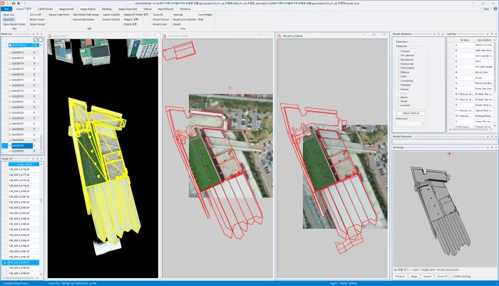
Geospatial Information-Based 3D Structure Modeling Solution
GEOSTORY Co., Ltd
This solution follows a three-step process of input, processing, and output, utilizing imagery, DEM, AT, and spatial data to refine 3D models. The editing-based texturing function allows users to correct shape errors, occlusions, and distortions, while the automated texturing ensures consistency and accuracy through advanced geometric matching. Final outputs are stored in standard formats for broad practical applications.
Pseudo-GNSS
GEOSTORY Co., Ltd
The Pseudo-GNSS system is designed with tightly integrated firmware and hardware.
The firmware generates PRN signals based on GNSS orbital data, modulates them to resemble real GNSS signals, and ensures time synchronization in a Master-Slave structure. A user-friendly GUI software enables easy device control.
The hardware consists of a power unit, signal transmission unit, and communication unit. The power unit ensures stable supply through low-noise design, while the transmission unit radiates GNSS-like signals indoors. The communication unit supports Wi-Fi and wired connections for synchronization and control across multiple devices, with compatibility for smartphones and tablets to display positioning results.
Bathymetric LiDAR System
GEOSTORY Co., Ltd
Our LiDAR uses a custom-designed laser that separates 1064 nm and 532 nm wavelengths from a single source, with two dedicated receivers capturing each set of data independently.
Inside the system, the linear laser beam is refracted at a 10-degree angle through a prism to enable circular scanning. An RF module is also integrated for real-time equipment status monitoring.
From circuit board design to component selection, every part of this system was developed in-house by multiple institutions.
As a result, we have successfully eliminated reliance on foreign technology.
People


About
Geostory Co., Ltd. is the only company in Korea that possesses technology that encompasses all processes of spatial information, from raw data production to management, processing, and solution development in all areas including the sky, land, and sea.
Through this accumulated know-how, we are providing high-quality data services to public institutions and private companies.
Spatial information is an essential element of future technological development. In the coming future, we plan to expand our business and secure new growth engines by converging future technologies based on our current technological capabilities.
We will continue to provide accurate and reliable spatial information and contribute to realizing a world where everything is connected.